![](/images/other/stat-length.png)
![Randonnée Marche West Cork - Hungry Hill - Photo](https://media.geolcdn.com/t/1900/400/d0b58611-9340-4ec7-9d97-0e843f5725a3.jpg&format=pjpeg&maxdim=2)
Hungry Hill
Geert H.
Utilisateur
![Longueur](/images/other/stat-length.png)
Longueur
12,3 km
![Altitude max](https://static1.geolcdn.com/siteimages/upload/files/1508320355ic_sort_altitude_max_24dp.png)
Altitude max
679 m
![Dénivelé positif](https://static1.geolcdn.com/siteimages/upload/files/1508320355ic_sort_den_pos_24dp.png)
Dénivelé positif
624 m
![Km-Effort](/images/other/stat-length.png)
Km-Effort
21 km
![Altitude min](https://static1.geolcdn.com/siteimages/upload/files/1508320355ic_sort_altitude_min_24dp.png)
Altitude min
31 m
![Dénivelé négatif](https://static1.geolcdn.com/siteimages/upload/files/1508320355ic_sort_den_neg_24dp.png)
Dénivelé négatif
693 m
![Boucle](https://static1.geolcdn.com/siteimages/upload/files/16400158638029165_repeat_loop_refresh_sync_direction_icon.png)
Boucle
Non
Date de création :
2024-08-17 08:52:57.032
Dernière modification :
2024-08-23 10:07:06.85
![Marche](https://static1.geolcdn.com/sitytour/trail-icons/101.png)
3h51
Difficulté : Difficile
![Scannez ce code QR pour ouvrir la randonnée dans l'application SityTrail](https://capi.geolives.com/qq0zvz2zws4bq2lad0pu/sitytour/trails/4158710/qr.png?size=200)
Application GPS de randonnée GRATUITE
À propos
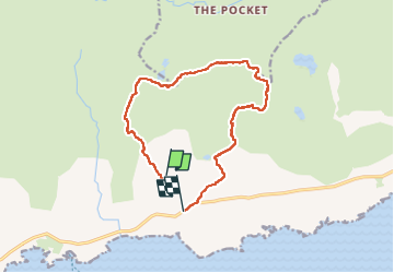
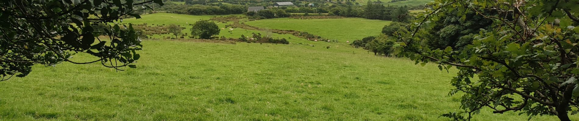
Randonnée Marche de 12,3 km à découvrir à Inconnu, County Cork, West Cork. Cette randonnée est proposée par Geert H..
Description
Beware, this trail is impossible to follow when the visibility is poor. The markings uphill to the top are barely visible red paint markers or stone cairns. The path from the top downhill is not marked and was followed by following the "path" on the openstreet map and GPS. But it is adventurous to say at least.
Localisation
Pays :
Irlande
Région :
Inconnu
Département/Province :
County Cork
Commune :
West Cork
Localité :
Curryglass
Départ:(Dec)
Départ:(UTM)
442962 ; 5724521 (29U) N.
Commentaires
Randonnées à proximité
![Randonnée Marche West Cork - All Rerrin Loop - Photo](https://media.geolcdn.com/t/375/260/ext.jpg?maxdim=2&url=https%3A%2F%2Fstatic1.geolcdn.com%2Fsiteimages%2Fupload%2Ffiles%2F1553511878bg_sport_marche.png)
![Marche Marche](https://static1.geolcdn.com/sitytour/trail-icons/101.png)
All Rerrin Loop
Marche
Facile
West Cork,
Inconnu,
County Cork,
Irlande
![](/images/other/stat-length.png)
6,4 km | 7,8 km-effort
Inconnu
![](https://static1.geolcdn.com/siteimages/upload/files/16400158638029165_repeat_loop_refresh_sync_direction_icon.png)
Oui